The storied Karakoram Highway (KKH), a modern incarnation of the ancient silk road, is the primary ground transport link between China and Pakistan, and the highest paved road in the world. The existing Highway, completed in 1978, is undergoing a major reconstruction. Along with other transport and energy development projects, the Highway upgrade is aimed at promoting economic development for the two countries. But if those projects work they will also bind them more closely strategically, and strengthen the writ of the state in sparsely-populated restive regions of both countries.
This photo essay illustrates some of those issues. The photos were taken in early July 2016, when I and my party drove along the entire Chinese part of the Karakoram Highway, from Kashgar to the Pakistani border.
[[{"fid":"184336","view_mode":"default","fields":{"format":"default","alignment":"","field_file_image_alt_text[und][0][value]":false,"field_file_image_title_text[und][0][value]":false},"type":"media","field_deltas":{"2":{"format":"default","alignment":"","field_file_image_alt_text[und][0][value]":false,"field_file_image_title_text[und][0][value]":false}},"link_text":null,"attributes":{"height":449,"width":800,"class":"media-element file-default","data-delta":"2"}}]]
Near the Ulug Rabat Pass (elevation 4098m), about 212km from the start of the Highway in Kashgar.
The Karakoram Highway snakes its way through the region known as 'the roof of the world,' at the junction of several of the highest mountain ranges in the world, including the Pamirs, Hindu Kush, Kunlun, and Karakoram ranges. It follows one of the paths of the ancient silk road, along which precious commodities, as well as art, Buddhism and Islam, were transmitted between China and Central and South Asia.
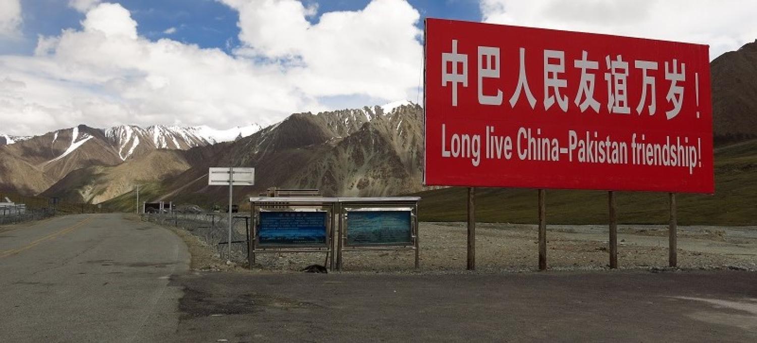
[[{"fid":"184341","view_mode":"default","fields":{"format":"default","alignment":"","field_file_image_alt_text[und][0][value]":false,"field_file_image_title_text[und][0][value]":false},"type":"media","field_deltas":{"3":{"format":"default","alignment":"","field_file_image_alt_text[und][0][value]":false,"field_file_image_title_text[und][0][value]":false}},"link_text":null,"attributes":{"height":449,"width":800,"class":"media-element file-default","data-delta":"3"}}]]
The Khunjerab Pass border crossing between China and Pakistan, the highest point on the road (elevation 4693m).
The Karakoram Highway is the existing nucleus around which China plans to finance and build better connectivity with its ally, Pakistan. The China-Pakistan Economic Corridor (CPEC), as it is known, is a $46 billion program of planned energy and transport infrastructure development in Pakistan, which in turn forms a key branch of China's 'One Belt One Road' initiative. With a vastly expanded Gwadar sea port at CPEC's southern tip, and a bundle of new roads, railways, and oil and gas pipelines, China seeks to establish new access to trade and energy from Southwest Asia. CPEC is ostensibly designed to provide economic development and stability to Pakistan, but will invariably also extend China's influence into South Asia, and it carries political risks for Pakistan.
[[{"fid":"184351","view_mode":"default","fields":{"format":"default","alignment":"","field_file_image_alt_text[und][0][value]":false,"field_file_image_title_text[und][0][value]":false},"type":"media","field_deltas":{"4":{"format":"default","alignment":"","field_file_image_alt_text[und][0][value]":false,"field_file_image_title_text[und][0][value]":false}},"link_text":null,"attributes":{"height":449,"width":800,"class":"media-element file-default","data-delta":"4"}}]]
A Kyrgyz yurt, on the shore of Karakul Lake (elevation 3600m), beneath the glaciated peak of Muztagh Ata (elevation 7509m).
The Karakoram Highway connects previously isolated small communities in sparsely-populated Xinjiang. These include not only the dominant Uyghur ethnic minority, but also Kyrgyz and Tajik minorities. Some, such as this hamlet of Kyrgyz families by Karakul Lake, still live in semi-permanent traditional herding villages. But the Highway has enabled greater trade and communication with other communities, as well as greater access for the Chinese state.
[[{"fid":"184356","view_mode":"default","fields":{"format":"default","alignment":"","field_file_image_alt_text[und][0][value]":false,"field_file_image_title_text[und][0][value]":false},"type":"media","field_deltas":{"5":{"format":"default","alignment":"","field_file_image_alt_text[und][0][value]":false,"field_file_image_title_text[und][0][value]":false}},"link_text":null,"attributes":{"height":449,"width":800,"class":"media-element file-default","data-delta":"5"}}]]
A segment of the Karakoram Highway being upgraded, showing the old road (left) and the new realigned roadway (right).
The reconstruction of the Highway, in both China and Pakistan, began in 2010, and is proceeding in sections. As of early July 2016, we observed a stretch of about 80-85km under construction, from the dam at Bulunkou lake, eastward through the Gez River valley. Widening and realigning (that is, re-routing) the road – especially by eliminating the perilous old switchbacks on mountainsides – will allow larger vehicles, including those carrying 40-foot shipping containers, to navigate the road, greatly increasing commercial traffic capacity. And a sealed metalled surface, which would allow snow ploughs to operate, will allow the road to be an all-weather link passable all year. Most of the new road will have two lanes with shoulders; increasing to four lanes in population centres such as Kashgar and Tashgurkan.
[[{"fid":"184361","view_mode":"default","fields":{"format":"default","alignment":"","field_file_image_alt_text[und][0][value]":false,"field_file_image_title_text[und][0][value]":false},"type":"media","field_deltas":{"6":{"format":"default","alignment":"","field_file_image_alt_text[und][0][value]":false,"field_file_image_title_text[und][0][value]":false}},"link_text":null,"attributes":{"height":449,"width":800,"class":"media-element file-default","data-delta":"6"}}]]
Elevated roadway under construction, Gez River valley.
Large sections of the upgrade involve the construction of a brand new elevated roadway, to escape the threats of landslides and seasonal flooding. These threats were vividly realised in Pakistan in 2010, when landslides destroyed villages and submerged a segment of the Karakoram Highway near Attabad. The Highway remained cut, interrupted by the newly created Attabad Lake, until China rebuilt the road, including with five new tunnels through adjacent mountainsides. These new Pakistan-China Friendship Tunnels were inaugurated in September 2015.
Part two of this photo essay can be found here.
